“In situations where a specific hazard has not been experienced, planning provides the opportunity to anticipate conditions and systematically identify potential problems and workable solutions.[i]”
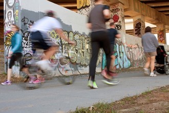 The Atlanta BeltLine is a walkable and bikeable path that connects neighborhoods, providing residents and visitors an attractive alternative to driving. When complete, the Atlanta Beltline can unify once divided areas, engendering greater community connectedness and economic viability. It weaves under, over, and through a multitude of overpasses, footbridges, and tunnels. As in any city, a significant feature is simultaneously an asset and a potential hazard. These types of structures are “vulnerable critical facilities” that should be included in emergency risk assessments and mitigation planning.[ii] Bridges of the BeltLine is a mixed-methods study to understand how the BeltLine can be used as an emergency management asset.
The project’s findings could break new ground on how to analyze the emergency use of similar pathways, at a time when many cities are looking at rails-to-trails projects. As such, this project is responsive to the United Nations’ sustainable goals nine “Build resilient infrastructure, promote inclusive and sustainable industrialization and foster innovation[iii]” and eleven “Make cities and human settlements inclusive, safe, resilient and sustainable.[iv]” The work of Bridges of the BeltLine is scalable to encompass the fully developed Atlanta BeltLine eventually, and its findings can be transferable to other cities around the nation and globe which have similar multi-use pedestrian pathways.
This preliminary study, specifically the findings from the BeltLine Bridge audit, lays the foundation for the future development of IoT Bridge monitoring that will provide knowledge of bridge structural changes over time as well as enhance traffic awareness and safety for pedestrians. When the initial people flow phase is complete, we will address automotive + pedestrian traffic via a coordinated deploy of a wireless sensor network.
April 2022 Final Report Abstract
Urban pedestrian flow, in general, has been under-funded and understudied but is nonetheless critical to city infrastructure monitoring and improvement projects. Conversely, human mobility patterns for emergency management purposes have been explored in a growing body of literature. Studies suggest that the Internet of Things technologies can play a significant role. This project focuses on the development of inexpensive, low power consumption sensors capable of detecting human presence while preserving privacy as a potential method of realtime data collection of pedestrian mobility along the Atlanta BeltLine, a pedestrian-centric transportation corridor.
Final Report: Bridges of the Beltline
Principal Investigators:
Salimah LaForce, Center for Advanced Communications Policy
Jeff Evans, Georgia Tech Research Institute, CDAIT
Scott Gilliland, Interactive Media Technology Center
This research is made possible by a grant from Georgia Tech’s Executive Vice President of Research, Small Bets Seed Grants program.
[i] FEMA. (2010). Comprehensive Preparedness Guide (CPG) 101, Version 2.0, Developing and Maintaining Emergency Operations Plans. Available at https://www.hsdl.org/?abstract&did=736560
[ii] FEMA. (2013). Mitigation ideas: A resource for reducing risk to natural disasters. Available at www.fema.gov › fema_mitigation_ideas_final_01252013
[iii] UN 17 Sustainable Global Development Goals. Available at https://www.un.org/development/desa/disabilities/envision2030-goal9.html
[iv] UN 17 Sustainable Global Development Goals. Available at https://www.un.org/development/desa/disabilities/envision2030-goal11.html